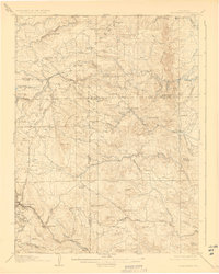
1906 Map of Blackhawk
USGS Topo · Published 1927About this map
The Colorado Central and Denver and Salt Lake railroads provide a critical look at the industrial pulse of this mountain corridor in the early twentieth century. These rail lines follow the deep drainages of South Boulder Creek and Clear Creek, connecting mining centers like Blackhawk with the wider region. The landscape is defined by a dense network of family-held ranches and small settlements, including Skate Ranch, Winiger Ranch, and Centennial Ranch, which were established alongside the more permanent structures of the Pine Glade School.
Find a feature on this map
45 named features on this map. Tap any name to fly to it.
Don’t see what you’re looking for? This feature index may not catch every label — zoom into the map to look around manually.
Map Details
Editions of this 1906 Blackhawk Map
5 editions found
Other maps of this area

1899 · West Denver
USGS Topo · 1:125,000

1902 · Boulder
USGS Topo · 1:62,500

1903 · Georgetown
USGS Topo · 1:62,500

1904 · Niwot
USGS Topo · 1:62,500

1904 · Boulder
USGS Topo · 1:62,500

1905 · Central City
USGS Topo · 1:62,500

1905 · Georgetown
USGS Topo · 1:62,500

1906 · Blackhawk
USGS Topo · 1:62,500

1910 · Central City
USGS Topo · 1:62,500

1912 · Central City
USGS Topo · 1:62,500