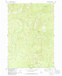
1973 Map of Blackmare
USGS Topo · Published 1991About this map
Payette National Forest and Boise National Forest converge in this high-altitude 1973 survey, capturing a wild landscape of the Idaho backcountry defined by its lookouts and primitive trail networks. The quadrangle is anchored by the dual observation points at Miners Peak Lookout and Blackmare Lookout, which overlook a complex hydrology of glacial lakes including Dismal Lake, Bills Lake, and Stump Lake. The terrain is characterized by sharp summits like Square Top and Needles Summit, while the drainage systems of Kennally Creek and Buckhorn Creek provide the primary corridors for travel. A network of routes, including the White Rock Peak Cutoff Trail and various unnamed pack trails, reveals the foot-and-horse transit patterns typical of this era in the national forests before significant road development altered the character of the drainage basins.
Find a feature on this map
33 named features on this map. Tap any name to fly to it.
Don’t see what you’re looking for? This feature index may not catch every label — zoom into the map to look around manually.
Map Details
Editions of this 1973 Blackmare Map
2 editions found
Other maps of this area

1954 · Gold Fork
USGS Topo · 1:62,500

1954 · Warm Lake
USGS Topo · 1:62,500

1957 · Challis
USGS Topo · 1:250,000

1960 · Challis
USGS Topo · 1:250,000

1963 · Challis
USGS Topo · 1:250,000

1973 · Blackmare
USGS Topo · 1:24,000

1973 · White Rock Peak
USGS Topo · 1:24,000

1973 · Fitsum Peak
USGS Topo · 1:24,000
1973 · Paddy Flat
USGS Topo · 1:24,000
1973 · Teapot Mtn
USGS Topo · 1:24,000