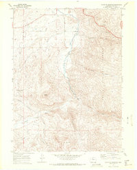
1969 Map of Blacktail Mountain
USGS Topo · Published 1972About this map
Pleasant Valley serves as the central drainage for this section of the Routt National Forest during the late 1960s, where the Yampa River meanders through a landscape defined by significant elevation changes. This survey provides a record of early water management and recreational development in the region, featuring the Suttle Ditch in the north and several streams such as Grouse Creek, Harrison Creek, and Service Creek feeding the river valley. The map is particularly useful for identifying the specific locations of the Ferndale Picnic Area and Harrison Creek Picnic Area, along with topographic landmarks like Blacktail Mountain and Woodchuck Hill. For those studying land use, the presence of a Gaging Sta along the river and various Jeep Trails provides evidence of how this high-country terrain was managed and accessed before more modern developments took root.
Find a feature on this map
21 named features on this map. Tap any name to fly to it.
Don’t see what you’re looking for? This feature index may not catch every label — zoom into the map to look around manually.
Map Details
Editions of this 1969 Blacktail Mountain Map
2 editions found
Other maps of this area

1954 · Craig
USGS Topo · 1:250,000

1956 · Storm Mountain
USGS Topo · 1:24,000

1956 · Walton Peak
USGS Topo · 1:24,000

1956 · Gore Pass
USGS Topo · 1:62,500

1956 · Rabbit Ears Peak
USGS Topo · 1:62,500

1957 · Craig
USGS Topo · 1:250,000

1958 · Craig
USGS Topo · 1:250,000

1960 · Craig
USGS Topo · 1:250,000

1962 · Craig
USGS Topo · 1:250,000

1964 · Craig
USGS Topo · 1:250,000