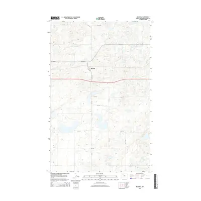
2014 Map of Blaisdell
USGS Topo · Published 2014About this map
Blaisdell serves as the central point of this North Dakota landscape, situated along the primary transportation corridors of Mountrail County. This 2014 survey captures the rural infrastructure of the region, where the modern roadway system parallels the historical route of Old Highway 2. The map reveals a highly structured grid of section lines and township roads, such as 60th St NW and 66th St NW, which define the agricultural layout of the plains. Beyond the main thoroughfares, smaller paths like Prairie Trl and the well-maintained Cr-3337 provide access to the outlying prairie lands. The numerous small, unnamed water bodies and wetlands scattered across the terrain highlight the glaciated topography characteristic of the northern plains, showing how human settlement and road networks have adapted to these natural depressions.
Find a feature on this map
16 named features on this map. Tap any name to fly to it.
Don’t see what you’re looking for? This feature index may not catch every label — zoom into the map to look around manually.
Map Details
Editions of this 2014 Blaisdell Map
This is the sole edition of this map. No revisions or reprints were ever made.
Other maps of this area

1953 · Williston
USGS Topo · 1:250,000

1954 · Minot
USGS Topo · 1:250,000

1957 · Williston
USGS Topo · 1:250,000

1958 · Minot
USGS Topo · 1:250,000

1980 · Minot
USGS Topo · 1:100,000
1980 · Aurelia
USGS Topo · 1:24,000

1980 · Tagus
USGS Topo · 1:24,000
1981 · Palermo NE
USGS Topo · 1:24,000

1981 · Palermo
USGS Topo · 1:24,000
1981 · Shell Lake
USGS Topo · 1:24,000