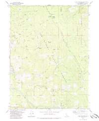
1979 Map of Blake Mountain
USGS Topo · Published 1985About this map
Six Rivers National Forest and Trinity National Forest meet along a ridge-dominated landscape in this 1970s survey. The area is defined by a dense network of high ridges, including Pilot Ridge, Hazen Ridge, and Bailey Ridge, which provide the foundation for a legacy of backcountry occupation. Cultural remnants are scattered throughout the forest, such as the Becker Cabin (Site) and the Becker Racetrack, suggesting a history of high-altitude ranching or recreational use.
Find a feature on this map
53 named features on this map. Tap any name to fly to it.
Don’t see what you’re looking for? This feature index may not catch every label — zoom into the map to look around manually.
Map Details
Editions of this 1979 Blake Mountain Map
3 editions found
Other maps of this area

1909 · Big Bar
USGS Topo · 1:96,000

1914 · Pilot Creek
USGS Topo · 1:62,500

1915 · Big Bar and Vicinity
USGS Topo · 1:250,000

1918 · Anada
USGS Topo · 1:62,500

1931 · Hoaglin
USGS Topo · 1:96,000

1935 · Hoaglin
USGS Topo · 1:125,000

1949 · Blocksburg
USGS Topo · 1:62,500

1951 · Blocksburg
USGS Topo · 1:62,500

1951 · Pilot Creek
USGS Topo · 1:62,500

1951 · Hyampom
USGS Topo · 1:62,500