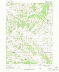
1968 Map of Blakesburg
USGS Topo · Published 1971About this map
Blakesburg and the surrounding farm country of southern Iowa are defined by a complex network of stream valleys and agricultural boundaries during the late 1960s. The township lines of Mantua, Urbana, and Union intersect at a triple-county corner where Monroe, Wapello, and Appanoose counties meet. This geography created a localized community identity anchored by several rural burying grounds, including Caldwell Cem, Eslinger Cem, and Sales Cem, which serve as vital markers for local family history.
Find a feature on this map
25 named features on this map. Tap any name to fly to it.
Don’t see what you’re looking for? This feature index may not catch every label — zoom into the map to look around manually.
Map Details
Editions of this 1968 Blakesburg Map
2 editions found
Other maps of this area

1929 · Albia
USGS Topo · 1:62,500

1939 · Mystic
USGS Topo · 1:62,500

1942 · Mystic
USGS Topo · 1:62,500

1954 · Centerville
USGS Topo · 1:250,000

1954 · Des Moines
USGS Topo · 1:250,000

1956 · Des Moines
USGS Topo · 1:250,000

1957 · Des Moines
USGS Topo · 1:250,000

1957 · Centerville
USGS Topo · 1:250,000

1958 · Centerville
USGS Topo · 1:250,000

1966 · Hiattsville
USGS Topo · 1:24,000