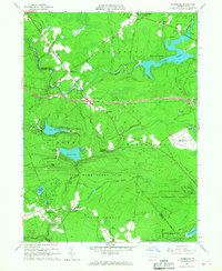
1965 Map of Blakeslee
USGS Topo · Published 1967About this map
Pocono International Raceway appears here in the mid-1960s as it is being carved into the landscape of Tunkhannock and Kidder townships. This era captures a dramatic transformation of the Poconos from a timber and hunting wilderness into a recreation-centered economy. The development of Locust Lakes Village and the expansion of Big Boulder Ski Resort signal the arrival of the modern vacation community era, while the newly mapped 80 and Interchange 43 provide the high-speed transit necessary for this growth.
Find a feature on this map
67 named features on this map. Tap any name to fly to it.
Don’t see what you’re looking for? This feature index may not catch every label — zoom into the map to look around manually.
Map Details
Editions of this 1965 Blakeslee Map
4 editions found
Other maps of this area

1914 · Wind Gap
USGS Topo · 1:62,500

1916 · Wind Gap
USGS Topo · 1:62,500

1919 · Pocono
USGS Topo · 1:62,500

1921 · Pocono
USGS Topo · 1:62,500

1922 · Mauch Chunk
USGS Topo · 1:62,500

1922 · Stoddartsville
USGS Topo · 1:62,500

1923 · Pocono
USGS Topo · 1:62,500

1924 · Stoddartsville
USGS Topo · 1:62,500

1924 · Mauch Chunk
USGS Topo · 1:62,500

1943 · Scranton
USGS Topo · 1:125,000
Featured Places
- Kidder Township, PA
- Pocono Pines, Tobyhanna Township
- Penn Forest Township, PA
- Tobyhanna Township, PA
- Tunkhannock Township, PA