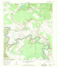
1960 Map of Blanchard
USGS Topo · Published 1969About this map
Blanchard sits at the northern edge of this 1960s landscape, which is defined by the winding course of the Trinity River as it snakes between Polk and San Jacinto counties. The river valley is a complex network of oxbows and backwaters, including Alligator Hole, Cochran Lake, and Penwa Slough, reflecting a dynamic riparian environment before modern water management significantly altered these natural floodplains.
Find a feature on this map
32 named features on this map. Tap any name to fly to it.
Don’t see what you’re looking for? This feature index may not catch every label — zoom into the map to look around manually.
Map Details
Editions of this 1960 Blanchard Map
Other maps of this area

1954 · Beaumont
USGS Topo · 1:250,000

1955 · New Willard
USGS Topo · 1:62,500

1957 · Beaumont
USGS Topo · 1:250,000

1958 · Livingston
USGS Topo · 1:62,500

1960 · Blanchard
USGS Topo · 1:24,000

1960 · Carlisle
USGS Topo · 1:24,000

1960 · Stephen Creek
USGS Topo · 1:24,000

1960 · Camilla
USGS Topo · 1:24,000

1960 · Coldspring
USGS Topo · 1:24,000

1961 · Onalaska
USGS Topo · 1:24,000