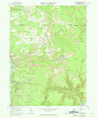
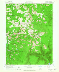
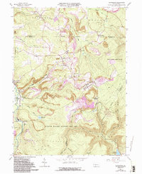
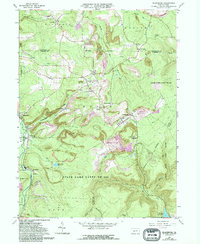
1963 Map of Blandburg
USGS Topo · Published 1973About this map
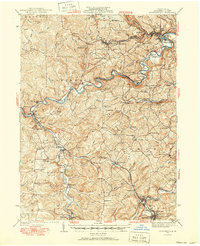
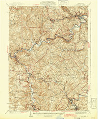
Strip mines and industrial activity dominate the landscape of this region during the early 1960s, particularly along the Penn Central rail lines. The map reveals a high concentration of extraction-related features, including numerous tipples and excavations that intersect with established communities like Blandburg and Frugality. In this coal-country environment, the proximity of Township High Sch to active mining sites illustrate the tight integration of industry and daily life. Local history is anchored by several rural burial grounds such as Creswell Cem and Cambria Mills Cem, which remain as markers of earlier generations. To the south, the terrain descends toward the Bellwood Reservoir, while large tracts are preserved as State Game Lands No 108, showcasing the dual character of a landscape utilized for both heavy industry and outdoor recreation.
Find a feature on this map
48 named features on this map. Tap any name to fly to it.
Don’t see what you’re looking for? This feature index may not catch every label — zoom into the map to look around manually.
Map Details
Editions of this 1963 Blandburg Map
4 editions found
Other maps of this area

1902 · Patton
USGS Topo · 1:62,500

1903 · Curwensville
USGS Topo · 1:62,500

1903 · Houtzdale
USGS Topo · 1:62,500

1904 · Patton
USGS Topo · 1:62,500

1905 · Houtzdale
USGS Topo · 1:62,500

1920 · Altoona
USGS Topo · 1:62,500

1922 · Altoona
USGS Topo · 1:62,500
1939 · Curwensville
USGS Topo · 1:62,500
1942 · Curwensville
USGS Topo · 1:62,500

1943 · Punxsutawney
USGS Topo · 1:125,000
Featured Places
- Beccaria Township, PA
- Dean Township, PA
- Clearfield Township, PA
- Gulich Township, PA
- Utahville, Beccaria Township