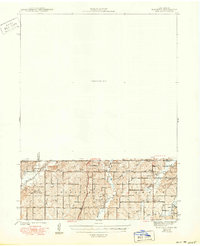
1943 Map of Blockton
USGS Topo · Published 1950About this map
The borderlands between Iowa and Missouri come to life in this 1940 topographic survey, showing a landscape defined by the branching waters of the Grand River. In this era before widespread rural consolidation, the map reveals a dense network of one-room schoolhouses such as Pleasant Valley Sch, Honey Grove Sch, and Victory Sch, which served the farming families of the Fletchall and Smith townships. The tiny settlement of Irena sits near the center of the sheet, connected to the wider world by the Chicago Burlington and Quincy railroad line.
Find a feature on this map
30 named features on this map. Tap any name to fly to it.
Don’t see what you’re looking for? This feature index may not catch every label — zoom into the map to look around manually.
Map Details
Editions of this 1943 Blockton Map
3 editions found
Other maps of this area

1940 · Blockton
USGS Topo · 1:62,500

1940 · Bedford
USGS Topo · 1:62,500

1940 · Parnell
USGS Topo · 1:62,500

1942 · Grant City
USGS Topo · 1:62,500

1943 · Bedford
USGS Topo · 1:62,500

1943 · Parnell
USGS Topo · 1:62,500

1943 · Grant City
USGS Topo · 1:62,500

1943 · Blockton
USGS Topo · 1:62,500

1945 · Mount Ayr
USGS Topo · 1:62,500

1947 · Mount Ayr
USGS Topo · 1:62,500