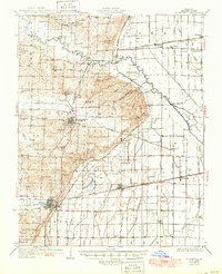
1934 Map of Bloomfield
USGS Topo · Published 1950About this map
Bloomfield serves as the central hub of this Missouri landscape, situated where the rolling uplands meet the heavily engineered drainage systems of the southeast plains. The map reveals an intricate network of water management, with numerous numbered channels like Ditch No 34 and Ditch No 1 redirecting the flow around Clines Island and Panther Slough. This transition from hills to bottoms is reflected in the density of rural infrastructure, including a high concentration of country schools such as Gravel Hill Sch and Gum Point Sch.
Find a feature on this map
95 named features on this map. Tap any name to fly to it.
Don’t see what you’re looking for? This feature index may not catch every label — zoom into the map to look around manually.
Map Details
Editions of this 1934 Bloomfield Map
3 editions found
Other maps of this area

1931 · Sikeston
USGS Topo · 1:62,500

1934 · Morley
USGS Topo · 1:62,500

1934 · Bloomfield
USGS Topo · 1:62,500

1934 · Sikeston
USGS Topo · 1:62,500

1934 · Advance
USGS Topo · 1:62,500

1934 · Puxico
USGS Topo · 1:62,500

1935 · Zalma
USGS Topo · 1:62,500

1939 · Bloomfield
USGS Topo · 1:62,500

1939 · Sikeston
USGS Topo · 1:62,500

1939 · New Madrid
USGS Topo · 1:62,500