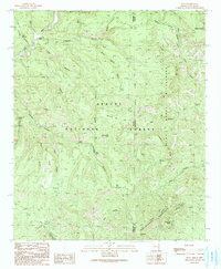
1991 Map of Blue
USGS Topo · Published 1991About this map
Apache National Forest straddles the high-altitude boundary between Greenlee County, Arizona, and Catron County, New Mexico. This 1991 provisional survey documents a landscape defined by deep drainages like Steeple Canyon and Cow Canyon that feed into the Blue River. The map highlights a network of water sources vital to the region's ranching and wilderness history, including Dutch Oven Spring, Cashier Spring, and Maverick Spring. High points such as WS Mountain and Whiterocks Mountain overlook the Blue Range Wilderness, where geological formations like Devils Monument rise above the Tige Rim. Settlement is sparse, represented primarily by the Jones Cemetery near the river, illustrating the solitary nature of life along the state line in the late 20th century.
Find a feature on this map
40 named features on this map. Tap any name to fly to it.
Don’t see what you’re looking for? This feature index may not catch every label — zoom into the map to look around manually.
Map Details
Editions of this 1991 Blue Map
This is the sole edition of this map. No revisions or reprints were ever made.
Other maps of this area

1910 · Mogollon
USGS Topo · 1:125,000

1912 · Mogollon
USGS Topo · 1:125,000

1913 · Morenci
USGS Topo · 1:125,000

1915 · Morenci
USGS Topo · 1:125,000

1915 · Reserve
USGS Topo · 1:125,000

1918 · Reserve
USGS Topo · 1:125,000

1922 · Nutrioso
USGS Topo · 1:125,000

1954 · Clifton
USGS Topo · 1:250,000

1957 · Clifton
USGS Topo · 1:250,000

1958 · Clifton
USGS Topo · 1:250,000