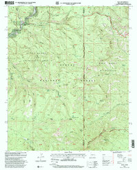
1997 Map of Blue
USGS Topo · Published 2000About this map
Marks Ranch and Campbell Flat anchor this high-elevation landscape along the Arizona-New Mexico state line in the late 1990s. The terrain is defined by the massive Tige Rim and the Blue Range, with the Blue River winding through the western canyons. This survey documents the protected wilderness of the Blue Primitive Area and the Blue Range Wilderness, showing an intricate network of drainage systems like Steeple Canyon and Lanphier Canyon. Local history and genealogy researchers can find family-named locations such as Jones Cemetery, as well as distinct landmarks like the Devils Monument rock formation. The map also records essential water sources for this arid environment, including Hinkle Springs, Franz Spring, and the high-altitude WS Lake near the summit of WS Mountain.
Find a feature on this map
50 named features on this map. Tap any name to fly to it.
Don’t see what you’re looking for? This feature index may not catch every label — zoom into the map to look around manually.
Map Details
Editions of this 1997 Blue Map
This is the sole edition of this map. No revisions or reprints were ever made.
Other maps of this area

1910 · Mogollon
USGS Topo · 1:125,000

1912 · Mogollon
USGS Topo · 1:125,000

1913 · Morenci
USGS Topo · 1:125,000

1915 · Morenci
USGS Topo · 1:125,000

1915 · Reserve
USGS Topo · 1:125,000

1918 · Reserve
USGS Topo · 1:125,000

1922 · Nutrioso
USGS Topo · 1:125,000

1954 · Clifton
USGS Topo · 1:250,000

1957 · Clifton
USGS Topo · 1:250,000

1958 · Clifton
USGS Topo · 1:250,000