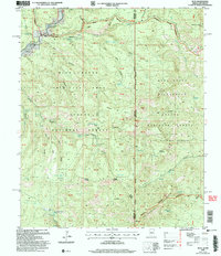
2005 Map of Blue
USGS Topo · Published 2006About this map
The Blue River corridor anchors this portion of the Apache National Forest, where the small settlement of Blue and the nearby Marks Ranch represent the primary human imprint on this remote landscape. The map captures a high-altitude borderland between Arizona and New Mexico, defined by the transition from the Blue Range Primitive Area to the Blue Range Rim Wilderness. Topographic details reveal a complex system of drainage and peaks, including Saddle Mountain Lookout and the striking Devils Monument. Local history and genealogy interests are served by the location of the Jones Cemetery near the river, while the presence of a Gravel Pit and various range infrastructure like Stateline Tank and the Alpine-Clifton Ranger District boundaries show the active management of these forest lands during the early 2000s.
Find a feature on this map
69 named features on this map. Tap any name to fly to it.
Don’t see what you’re looking for? This feature index may not catch every label — zoom into the map to look around manually.
Map Details
Editions of this 2005 Blue Map
This is the sole edition of this map. No revisions or reprints were ever made.
Other maps of this area

1910 · Mogollon
USGS Topo · 1:125,000

1912 · Mogollon
USGS Topo · 1:125,000

1913 · Morenci
USGS Topo · 1:125,000

1915 · Morenci
USGS Topo · 1:125,000

1915 · Reserve
USGS Topo · 1:125,000

1918 · Reserve
USGS Topo · 1:125,000

1922 · Nutrioso
USGS Topo · 1:125,000

1954 · Clifton
USGS Topo · 1:250,000

1957 · Clifton
USGS Topo · 1:250,000

1958 · Clifton
USGS Topo · 1:250,000