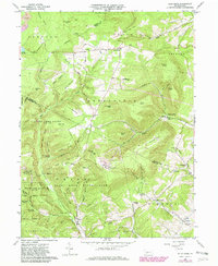
1963 Map of Blue Knob
USGS Topo · Published 1982About this map
Blue Knob State Park and State Game Lands No 26 dominate this 1963 survey of the Allegheny Front, where the borders of Blair, Bedford, and Cambria counties converge. The terrain is defined by dramatic ridgelines including Hog Back Ridge and Crist Ridge, with the high point of Blue Knob featuring a Ski Area and Lookout Tower.
Find a feature on this map
84 named features on this map. Tap any name to fly to it.
Don’t see what you’re looking for? This feature index may not catch every label — zoom into the map to look around manually.
Map Details
Editions of this 1963 Blue Knob Map
4 editions found
Other maps of this area

1900 · Everett
USGS Topo · 1:62,500

1902 · Everett
USGS Topo · 1:62,500

1902 · Ebensburg
USGS Topo · 1:62,500

1902 · Hollidaysburg
USGS Topo · 1:62,500

1903 · Hollidaysburg
USGS Topo · 1:62,500

1904 · Ebensburg
USGS Topo · 1:62,500

1908 · Bedford
USGS Topo · 1:62,500

1910 · Bedford
USGS Topo · 1:62,500

1953 · Pittsburgh
USGS Topo · 1:250,000

1954 · Pittsburgh
USGS Topo · 1:250,000
Featured Places
- Pavia Township, PA
- Freedom Township, PA
- Greenfield Township, PA
- Blue Knob, Juniata Township
- Washington Township, PA