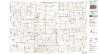
1986 Map of Blue Rapids
USGS Topo · Published 1990About this map
Tuttle Creek Lake dominates the southern reaches of this landscape, its expansive waters and the adjacent Tuttle Creek State Wildlife Area reshaping the original river valleys. The terrain is marked by significant historical waypoints, most notably Alcove Spring, a vital stop on the overland trails. The map reveals a dense network of late-20th-century townships such as Marysville, Blue Rapids, and Seneca, each serving as a hub for the surrounding agricultural grid.
Find a feature on this map
129 named features on this map. Tap any name to fly to it.
Don’t see what you’re looking for? This feature index may not catch every label — zoom into the map to look around manually.
Map Details
Editions of this 1986 Blue Rapids Map
2 editions found
Other maps of this area

1886 · Junction City
USGS Topo · 1:125,000

1888 · Hiawatha
USGS Topo · 1:125,000

1889 · Seneca
USGS Topo · 1:125,000

1889 · Wamego
USGS Topo · 1:125,000

1889 · Marysville
USGS Topo · 1:125,000

1889 · Junction City
USGS Topo · 1:125,000

1889 · Topeka
USGS Topo · 1:125,000

1891 · Clay Center
USGS Topo · 1:125,000

1893 · Washington
USGS Topo · 1:125,000

1894 · Junction City
USGS Topo · 1:125,000