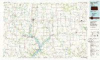
1986 Map of Blue Rapids
USGS Topo · Published 1986About this map
Marysville and Blue Rapids serve as the primary hubs in this mid-1980s landscape of Northeast Kansas, where the confluence of the Big Blue River and the Little Blue River shapes the local geography. The river systems define the region's character, particularly with the northern reaches of Tuttle Creek Lake and the Tuttle Creek State Wildlife Management Area extending into Marshall County. The Union Pacific railroad lines parallel the waterways and major roads like US Highway 36, tracing paths through established agricultural townships such as Herkimer, Guittard, and Vermillion.
Find a feature on this map
159 named features on this map. Tap any name to fly to it.
Don’t see what you’re looking for? This feature index may not catch every label — zoom into the map to look around manually.
Map Details
Editions of this 1986 Blue Rapids Map
2 editions found
Other maps of this area

1886 · Junction City
USGS Topo · 1:125,000

1888 · Hiawatha
USGS Topo · 1:125,000

1889 · Seneca
USGS Topo · 1:125,000

1889 · Wamego
USGS Topo · 1:125,000

1889 · Marysville
USGS Topo · 1:125,000

1889 · Junction City
USGS Topo · 1:125,000

1889 · Topeka
USGS Topo · 1:125,000

1891 · Clay Center
USGS Topo · 1:125,000

1893 · Washington
USGS Topo · 1:125,000

1894 · Junction City
USGS Topo · 1:125,000