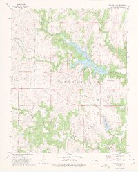
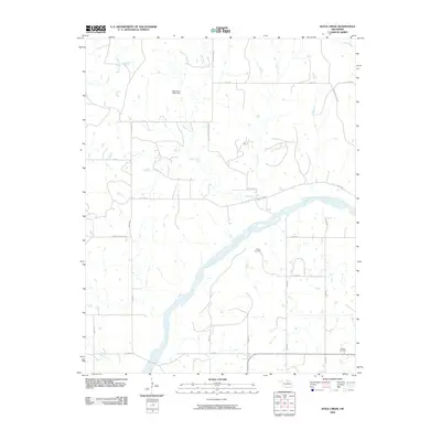
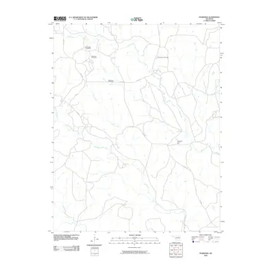
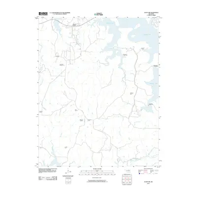
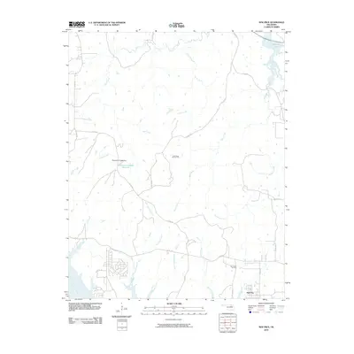
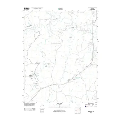
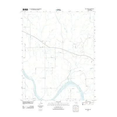
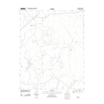
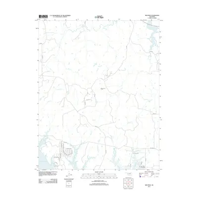
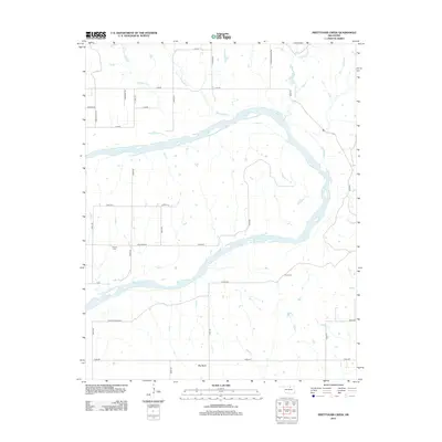
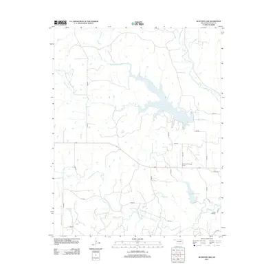
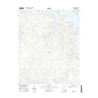
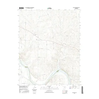
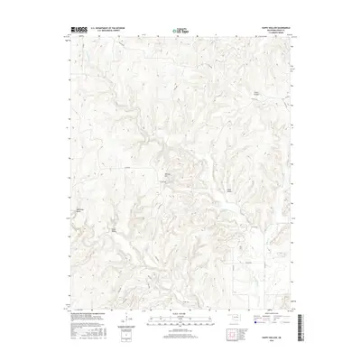
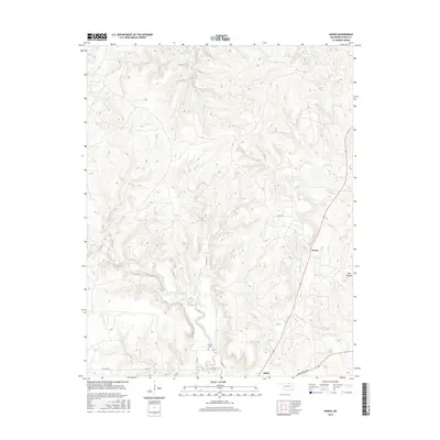
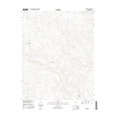
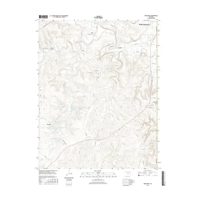
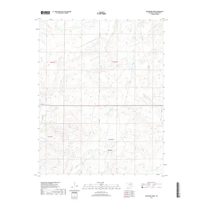
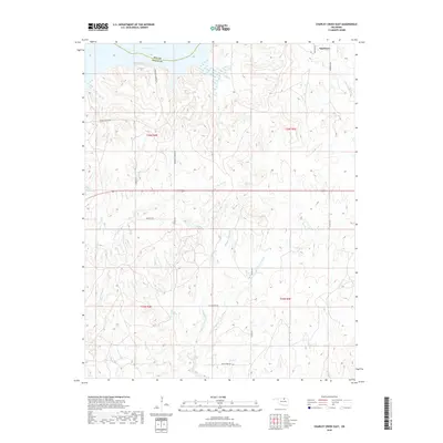
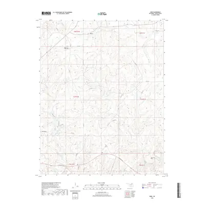
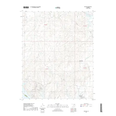
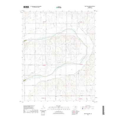
1973 Map of Bluestem Lake
USGS Topo · Published 1975About this map
Bluestem Lake and its surrounding watershed dominate this mid-1970s survey within the Osage Indian Reservation. The map documents a landscape defined by water management and mineral extraction, featuring the prominent reservoirs of Bluestem and Lake Pawhuska. The intricate drainage system includes Middle Bird Creek, South Bird Creek, and Maher Creek, while the presence of an extensive Oil Field and multiple Oil Wells highlights the region's industrial foundations. Significant land use markers include the Strike Axe area and the Pawhuska Municipal Airport, alongside smaller remnants of local history like a rural Cem and an Old Railroad Grade near Clear Creek. The transition from natural waterways to engineered spillways at both lakes illustrates the mid-century development of water resources in Osage County.
Find a feature on this map
26 named features on this map. Tap any name to fly to it.
Don’t see what you’re looking for? This feature index may not catch every label — zoom into the map to look around manually.
Map Details
Editions of this 1973 Bluestem Lake Map
2 editions found
Historical Maps of Osage County Through Time
152 maps found

1936 Belford
Osage County, OK

1958 Wekiwa
Osage County, OK

1960 Herd
Osage County, OK

1960 Nanos
Osage County, OK

1963 Avant SE
Osage County, OK

1963 Charley Creek West
Osage County, OK

1964 Charley Creek NE
Osage County, OK

1966 Avant NW
Osage County, OK

1966 Avant SW
Osage County, OK

1966 Hominy NE
Osage County, OK

1966 New Prue
Osage County, OK

1971 Bowring SE
Osage County, OK

1971 Woolaroc
Osage County, OK

1972 Wolco
Osage County, OK

1973 Bluestem Lake
Osage County, OK

1973 Foraker North
Osage County, OK

1973 Foraker South
Osage County, OK

1973 Happy Hollow
Osage County, OK

1973 Pearsonia NE
Osage County, OK

1973 Pearsonia NW
Osage County, OK

1973 Pearsonia
Osage County, OK

1978 Baconrind Creek
Osage County, OK

1978 Bug Creek
Osage County, OK

1978 Doga Creek
Osage County, OK

1978 Lucy Creek
Osage County, OK

1978 Prettyhair Creek
Osage County, OK

1990 Keystone Lake
Osage County, OK
2009 Baconrind Creek
Osage County, OK
2009 Bug Creek
Osage County, OK
2009 Charley Creek East
Osage County, OK
2009 Doga Creek
Osage County, OK
2009 Happy Hollow
Osage County, OK

2009 Hominy NE
Osage County, OK
2009 Lucy Creek
Osage County, OK
2009 Nanos
Osage County, OK
2009 Pearsonia
Osage County, OK
2009 Prettyhair Creek
Osage County, OK
2010 Avant NW
Osage County, OK
2010 Avant SE
Osage County, OK
2010 Avant SW
Osage County, OK
2010 Bluestem Lake
Osage County, OK
2010 Bowring SE
Osage County, OK

2010 Charley Creek West
Osage County, OK

2010 Foraker North
Osage County, OK

2010 Foraker South
Osage County, OK
2010 Herd
Osage County, OK
2010 New Prue
Osage County, OK
2010 Pearsonia NE
Osage County, OK
2010 Pearsonia NW
Osage County, OK

2010 Wekiwa
Osage County, OK
2010 Wolco
Osage County, OK
2010 Woolaroc
Osage County, OK
2012 Avant SE
Osage County, OK
2012 Baconrind Creek
Osage County, OK
2012 Bowring SE
Osage County, OK
2012 Bug Creek
Osage County, OK
2012 Charley Creek East
Osage County, OK

2012 Charley Creek West
Osage County, OK
2012 Doga Creek
Osage County, OK

2012 Foraker North
Osage County, OK

2012 Foraker South
Osage County, OK
2012 Happy Hollow
Osage County, OK
2012 Herd
Osage County, OK
2012 Hominy NE
Osage County, OK
2012 Lucy Creek
Osage County, OK
2012 Nanos
Osage County, OK
2012 New Prue
Osage County, OK
2012 Pearsonia NE
Osage County, OK
2012 Pearsonia NW
Osage County, OK
2012 Pearsonia
Osage County, OK
2012 Prettyhair Creek
Osage County, OK

2012 Wekiwa
Osage County, OK
2012 Woolaroc
Osage County, OK
2013 Avant NW
Osage County, OK
2013 Avant SW
Osage County, OK
2013 Bluestem Lake
Osage County, OK
2013 Wolco
Osage County, OK
2016 Avant NW
Osage County, OK
2016 Avant SE
Osage County, OK
2016 Avant SW
Osage County, OK
2016 Baconrind Creek
Osage County, OK
2016 Bluestem Lake
Osage County, OK
2016 Bowring SE
Osage County, OK
2016 Bug Creek
Osage County, OK
2016 Charley Creek East
Osage County, OK
2016 Charley Creek West
Osage County, OK
2016 Doga Creek
Osage County, OK

2016 Foraker North
Osage County, OK

2016 Foraker South
Osage County, OK
2016 Happy Hollow
Osage County, OK
2016 Herd
Osage County, OK
2016 Hominy NE
Osage County, OK
2016 Lucy Creek
Osage County, OK
2016 Nanos
Osage County, OK
2016 New Prue
Osage County, OK
2016 Pearsonia NE
Osage County, OK
2016 Pearsonia NW
Osage County, OK
2016 Pearsonia
Osage County, OK
2016 Prettyhair Creek
Osage County, OK
2016 Wekiwa
Osage County, OK
2016 Wolco
Osage County, OK
2016 Woolaroc
Osage County, OK
2018 Avant NW
Osage County, OK
2018 Avant SE
Osage County, OK
2018 Avant SW
Osage County, OK
2018 Baconrind Creek
Osage County, OK
2018 Bluestem Lake
Osage County, OK
2018 Bowring SE
Osage County, OK
2018 Bug Creek
Osage County, OK
2018 Charley Creek East
Osage County, OK
2018 Charley Creek West
Osage County, OK
2018 Doga Creek
Osage County, OK

2018 Foraker North
Osage County, OK

2018 Foraker South
Osage County, OK
2018 Happy Hollow
Osage County, OK
2018 Herd
Osage County, OK
2018 Hominy NE
Osage County, OK
2018 Lucy Creek
Osage County, OK
2018 Nanos
Osage County, OK
2018 New Prue
Osage County, OK
2018 Pearsonia NE
Osage County, OK
2018 Pearsonia NW
Osage County, OK
2018 Pearsonia
Osage County, OK
2018 Prettyhair Creek
Osage County, OK
2018 Wekiwa
Osage County, OK
2018 Wolco
Osage County, OK
2018 Woolaroc
Osage County, OK

2022 Avant NW
Osage County, OK

2022 Avant SE
Osage County, OK

2022 Avant SW
Osage County, OK

2022 Baconrind Creek
Osage County, OK

2022 Bluestem Lake
Osage County, OK

2022 Bowring SE
Osage County, OK

2022 Bug Creek
Osage County, OK

2022 Charley Creek East
Osage County, OK

2022 Charley Creek West
Osage County, OK

2022 Doga Creek
Osage County, OK

2022 Foraker North
Osage County, OK

2022 Foraker South
Osage County, OK

2022 Happy Hollow
Osage County, OK

2022 Herd
Osage County, OK

2022 Hominy NE
Osage County, OK

2022 Lucy Creek
Osage County, OK

2022 Nanos
Osage County, OK

2022 New Prue
Osage County, OK

2022 Pearsonia NE
Osage County, OK

2022 Pearsonia NW
Osage County, OK

2022 Pearsonia
Osage County, OK

2022 Prettyhair Creek
Osage County, OK

2022 Wekiwa
Osage County, OK

2022 Wolco
Osage County, OK

2022 Woolaroc
Osage County, OK