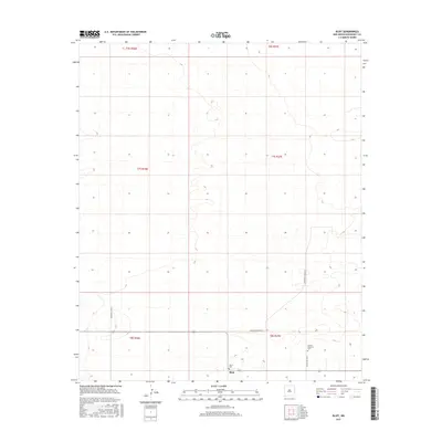
2017 Map of Bluit
USGS Topo · Published 2017About this map
Bluit stands as a quiet focus in this section of Roosevelt County, where the High Plains landscape is organized by the rigid lines of the Public Land Survey System. The map reveals a rural pattern of life centered on long-established sites of local memory, including the Bluit Cem and the Perkins Memorial Cem. These small cemeteries, along with the settlement itself, are connected by a geometric grid of county roads such as S Roosevelt Road 42 and S Roosevelt Rd G. This 2017 survey documents a high-desert environment defined by subtle elevation changes and township boundaries like t7s r37e, illustrating how human habitation and infrastructure in eastern New Mexico remain closely tied to the foundational land divisions of the American West.
Find a feature on this map
12 named features on this map. Tap any name to fly to it.
Don’t see what you’re looking for? This feature index may not catch every label — zoom into the map to look around manually.
Map Details
Editions of this 2017 Bluit Map
This is the sole edition of this map. No revisions or reprints were ever made.
Other maps of this area

1954 · Brownfield
USGS Topo · 1:250,000

1958 · Brownfield
USGS Topo · 1:250,000

1962 · Brownfield
USGS Topo · 1:250,000

1970 · Lingo
USGS Topo · 1:24,000

1970 · Bledsoe
USGS Topo · 1:24,000

1970 · Bledsoe NE
USGS Topo · 1:24,000

1972 · Bluit
USGS Topo · 1:24,000
1972 · Bledsoe SW
USGS Topo · 1:24,000

1972 · Garrison
USGS Topo · 1:24,000

1972 · Milnesand
USGS Topo · 1:24,000