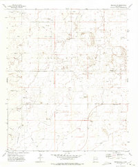
1972 Map of Bledsoe SW
USGS Topo · Published 1975About this map
The Allison Oil Field dominates this corner of the Llano Estacado, where industrial extraction and isolated rural education defined the mid-century landscape. Spanning the boundary of Roosevelt Co Lea Co, the map reveals a network of pipelines and service roads supporting various wells and a dedicated Gasoline Plant. This industrial footprint is interspersed with remnants of earlier settlement patterns, most notably the Pitchfork School situated in the eastern portion of the quadrangle. The terrain is characterized by numerous depressions and scattered Gravel Pit excavations, while the survey point at Sawyer and the northern reaches of the Crossroads area provide fixed landmarks in a relatively open expanse. The distribution of these features illustrates the transition from a traditional ranching economy to one centered on petroleum production and the extraction of local materials.
Find a feature on this map
7 named features on this map. Tap any name to fly to it.
Don’t see what you’re looking for? This feature index may not catch every label — zoom into the map to look around manually.
Map Details
Editions of this 1972 Bledsoe SW Map
2 editions found
Other maps of this area

1954 · Brownfield
USGS Topo · 1:250,000

1958 · Brownfield
USGS Topo · 1:250,000

1962 · Brownfield
USGS Topo · 1:250,000

1970 · Bronco NE
USGS Topo · 1:24,000

1970 · Walking Cane Ranch
USGS Topo · 1:24,000

1970 · Ranger Lake
USGS Topo · 1:24,000

1970 · Bledsoe
USGS Topo · 1:24,000

1970 · Bledsoe NE
USGS Topo · 1:24,000

1972 · Bluit
USGS Topo · 1:24,000

1972 · Milnesand
USGS Topo · 1:24,000