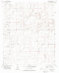
1972 Map of Bledsoe SW
USGS Topo · Published 1988About this map
Allison Oil Field dominates this High Plains landscape along the border of Roosevelt Co and Lea Co. The territory is defined by the heavy footprint of the petroleum industry during the early 1970s, characterized by a dense network of Oil Wells, multiple pipelines, and a specialized Gasoline Plant in the northwest. In addition to the industrial development, the map reveals isolated infrastructure such as Landing Strips and the Crossroads area.
Find a feature on this map
11 named features on this map. Tap any name to fly to it.
Don’t see what you’re looking for? This feature index may not catch every label — zoom into the map to look around manually.
Map Details
Editions of this 1972 Bledsoe SW Map
2 editions found
Other maps of this area

1954 · Brownfield
USGS Topo · 1:250,000

1958 · Brownfield
USGS Topo · 1:250,000

1962 · Brownfield
USGS Topo · 1:250,000

1970 · Bronco NE
USGS Topo · 1:24,000

1970 · Walking Cane Ranch
USGS Topo · 1:24,000

1970 · Ranger Lake
USGS Topo · 1:24,000

1970 · Bledsoe
USGS Topo · 1:24,000

1970 · Bledsoe NE
USGS Topo · 1:24,000

1972 · Bluit
USGS Topo · 1:24,000
1972 · Bledsoe SW
USGS Topo · 1:24,000