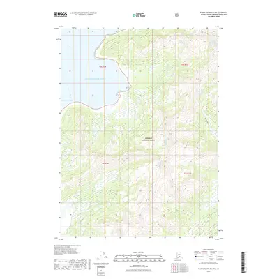
2018 Map of Blying Sound D-2 NW
USGS Topo · Published 2018About this map
Prince William Sound meets the Gulf of Alaska along this coast where glacial waters and steep terrain define the Chugach National Forest. The landscape is dominated by dynamic drainage systems, most notably the Patton River and the Nellie Martin River, which flow through deep valleys carved into the Kenai Peninsula. A single interior corridor, the Patton River Trail, provides the only marked terrestrial access through the dense coastal wilderness. The hydrography of the region is characterized by complex watercourses like Braided Cr, illustrating the active alluvial processes at work in this subarctic environment. This survey provides a precise look at the shifting shorelines and undeveloped watersheds of the Valdez-Cordova region as they appeared in the early 21st century.
Find a feature on this map
11 named features on this map. Tap any name to fly to it.
Don’t see what you’re looking for? This feature index may not catch every label — zoom into the map to look around manually.
Map Details
Editions of this 2018 Blying Sound D-2 NW Map
This is the sole edition of this map. No revisions or reprints were ever made.
Other maps of this area

1946 · Blying Sound
USGS Topo · 1:250,000

1951 · Blying Sound
USGS Topo · 1:250,000

1951 · Seward
USGS Topo · 1:250,000

1951 · Seward A-2
USGS Topo · 1:63,360

1951 · Seward A-3
USGS Topo · 1:63,360

1951 · Blying Sound D-1 and D-2
USGS Topo · 1:63,360

1952 · Seward A-3
USGS Topo · 1:63,360

1953 · Seward A-2
USGS Topo · 1:63,360
1953 · Blying Sound D-3
USGS Topo · 1:63,360
1953 · Blying Sound D-1 and D-2
USGS Topo · 1:63,360