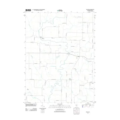
2012 Map of Blyton
USGS Topo · Published 2012About this map
The Spoon River snakes through the heart of this Fulton County landscape, carving a deep valley that includes the prominent Big Hollow. This 2012 survey illustrates a rural Illinois environment where agricultural heritage remains a defining characteristic, most notably at the Blout Centennial Farm. The river crossings at Babylon Bend Bridge and Ziltz Bridge serve as vital connectors for a grid of roads with distinctive local names like N Rattlesnake Rd and N Fox Trail Rd. For genealogists, the map is a primary resource for locating several smaller burial grounds, including Rigdon Cem, Wiley Cem, and Sinnett Chapel Cem. Small settlements like Babylon, Blyton, and Buckeye anchor the township, while smaller waterways such as Shoal Cr, Put Cr, and Laswell Br drain the surrounding fields into the primary river channel.
Find a feature on this map
69 named features on this map. Tap any name to fly to it.
Don’t see what you’re looking for? This feature index may not catch every label — zoom into the map to look around manually.
Map Details
Editions of this 2012 Blyton Map
This is the sole edition of this map. No revisions or reprints were ever made.
Other maps of this area

1912 · Canton
USGS Topo · 1:62,500

1915 · Avon
USGS Topo · 1:62,500

1918 · Vermont
USGS Topo · 1:62,500

1921 · Vermont
USGS Topo · 1:62,500

1925 · Havana
USGS Topo · 1:62,500

1944 · Avon
USGS Topo · 1:62,500

1947 · Lewistown
USGS Topo · 1:24,000

1947 · Adair
USGS Topo · 1:24,000

1948 · Lewistown
USGS Topo · 1:24,000
1948 · Adair
USGS Topo · 1:24,000