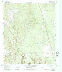
1959 Map of Bob Creek
USGS Topo · Published 1985About this map
Salt Fork Brazos River winds through the southern edge of this West Texas landscape, marking the transition between King and Stonewall Counties. The terrain is defined by a network of drainage systems, including Bob Creek and Brushy Creek, which carve through the plains toward the river. Human presence in the late 1950s is represented by sprawling livestock operations like the Martin Ranch and isolated water sources such as Brushy Tank and Negro Tank, essential for ranching in this arid region. Near the western boundary, the Gilkerson Cemetery offers a point of interest for genealogists, while the presence of an Oil Well near the center of the sheet indicates the early industrial footprint of petroleum exploration. The map also captures the path of Highway 83 as it bisects the ranch land, and identifies local landmarks like Deadmans Hole along the riverbanks.
Find a feature on this map
14 named features on this map. Tap any name to fly to it.
Don’t see what you’re looking for? This feature index may not catch every label — zoom into the map to look around manually.
Map Details
Editions of this 1959 Bob Creek Map
2 editions found
Other maps of this area

1954 · Lubbock
USGS Topo · 1:250,000

1958 · Southerland Canyon
USGS Topo · 1:24,000

1958 · Seven Diamond L Canyon
USGS Topo · 1:24,000

1958 · Lovers Resort
USGS Topo · 1:24,000

1959 · Bob Creek
USGS Topo · 1:24,000

1967 · Dark Canyon
USGS Topo · 1:24,000

1967 · Kiowa Peak NW
USGS Topo · 1:24,000

1967 · Kiowa Peak SW
USGS Topo · 1:24,000

1968 · Guthrie
USGS Topo · 1:24,000

1968 · Pitchfork Flats
USGS Topo · 1:24,000