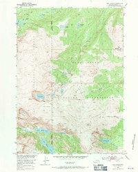
1952 Map of Bob Lakes
USGS Topo · Published 1971About this map
The high alpine Divide country of the Wind River Indian Reservation and Shoshone National Forest is defined here by its intricate glacial hydrology and surveying landmarks. In the early 1950s, the Meadow Creek Lookout Tower stood on the summit of Bold Mountain, serving as a critical fire watch point for the surrounding timber. The landscape transitions from the massive Kirkland Mountains down to a cluster of remote sub-alpine basins, where drainage systems like Bull Lake Creek and the various forks of Willow Creek originate. The presence of Indian Pass and high-altitude water bodies such as Crater Lake, Big Milky Lake, and Kirkland Lake illustrates the difficult terrain that historically separated these wilderness tracts. This 1952 record highlights the intersection of forest management and tribal land boundaries before modern development changed the character of backcountry access.
Find a feature on this map
27 named features on this map. Tap any name to fly to it.
Don’t see what you’re looking for? This feature index may not catch every label — zoom into the map to look around manually.
Map Details
Editions of this 1952 Bob Lakes Map
4 editions found
Other maps of this area

1909 · Fremont Peak
USGS Topo · 1:125,000

1952 · Hays Park
USGS Topo · 1:24,000

1952 · Bob Lakes
USGS Topo · 1:24,000

1952 · Burris
USGS Topo · 1:24,000

1952 · Kirkland Park
USGS Topo · 1:24,000

1952 · Paradise Basin
USGS Topo · 1:24,000

1952 · Alpine Lake
USGS Topo · 1:24,000

1955 · Thermopolis
USGS Topo · 1:250,000

1958 · Thermopolis
USGS Topo · 1:250,000

1962 · Thermopolis
USGS Topo · 1:250,000