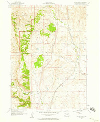
1957 Map of Boland Ridge
USGS Topo · Published 1958About this map
Wind Cave National Park occupies the northwestern corner of this landscape, where the high elevations of Boland Ridge overlook a network of seasonal drainages and geological formations. The topographic data, compiled in part for the United States Atomic Energy Commission, reveals a transition from the protected parklands into the managed ranching and transport corridors of Custer County. The Chicago and North Western railroad cuts a distinctive path through the eastern half of the map, following the contours near Lame Johnny Creek. This rail line was vital for connecting the Black Hills to broader markets during the mid-20th century. Notable terrain features such as Unkpapa Peak and Buffalo Gap mark the southern reaches, providing clear landmarks for tracing historic property lines or exploring the drainage patterns of Beaver Creek and Fuson Canyon.
Find a feature on this map
11 named features on this map. Tap any name to fly to it.
Don’t see what you’re looking for? This feature index may not catch every label — zoom into the map to look around manually.
Map Details
Editions of this 1957 Boland Ridge Map
2 editions found
Other maps of this area

1894 · Hermosa
USGS Topo · 1:125,000

1896 · Oelrichs
USGS Topo · 1:125,000

1900 · Oelrichs
USGS Topo · 1:125,000

1901 · Hermosa
USGS Topo · 1:125,000

1950 · Hot Springs
USGS Topo · 1:24,000

1950 · Buffalo Gap
USGS Topo · 1:24,000

1951 · Smithwick NW
USGS Topo · 1:24,000

1955 · Mt. Coolidge
USGS Topo · 1:24,000

1955 · Hot Springs
USGS Topo · 1:250,000
1957 · Wind Cave
USGS Topo · 1:24,000