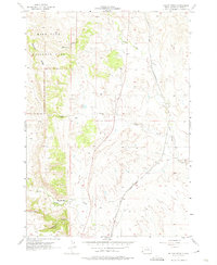
1957 Map of Boland Ridge
USGS Topo · Published 1974About this map
Wind Cave National Park dominates the northwestern portion of this mid-century survey, where the rugged topography of Boland Ridge descends toward the plains. This landscape is defined by its drainage patterns, with Blacktail Creek, Lame Johnny Creek, and Dry Creek carving deep paths through the terrain. The presence of the Chicago and North Western railroad line cutting through the eastern corridor illustrates the vital transit link connecting the Black Hills to the broader regional economy.
Find a feature on this map
16 named features on this map. Tap any name to fly to it.
Don’t see what you’re looking for? This feature index may not catch every label — zoom into the map to look around manually.
Map Details
Editions of this 1957 Boland Ridge Map
2 editions found
Other maps of this area

1894 · Hermosa
USGS Topo · 1:125,000

1896 · Oelrichs
USGS Topo · 1:125,000

1900 · Oelrichs
USGS Topo · 1:125,000

1901 · Hermosa
USGS Topo · 1:125,000

1950 · Hot Springs
USGS Topo · 1:24,000

1950 · Buffalo Gap
USGS Topo · 1:24,000

1951 · Smithwick NW
USGS Topo · 1:24,000

1955 · Mt. Coolidge
USGS Topo · 1:24,000

1955 · Hot Springs
USGS Topo · 1:250,000
1957 · Wind Cave
USGS Topo · 1:24,000