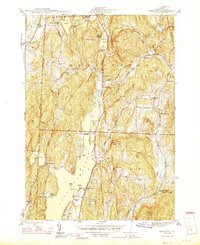
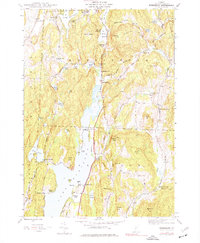
1944 Map of Bomoseen
USGS Topo · Published 1946About this map
Bomoseen Lake dominates this mid-1940s landscape, serving as a focal point for the surrounding settlements of Hubbardton, Hortonville, and West Castleton. The map documents a well-developed network of recreational and educational sites, from summer camps like Camp Awanee and Green Mtn Camp to a series of rural schoolhouses such as Banghall Sch and the Turnpike Sch. The topography is marked by named heights like Cedar Mtn and Eaton Hill, while the Monument Highway and Warner Memorial Highway provide the primary transit corridors through the valley. This era reveals a community transition from traditional agriculture toward seasonal lakeside recreation, evidenced by the proliferation of beaches like Crystal Beach, Avalon Beach, and Neshobe Beach. Genealogists will find value in the precise locations of the Pleasant View Cem and East Hubbardton Cem, alongside the St Matthews Ch near the lake's western shore.
Find a feature on this map
62 named features on this map. Tap any name to fly to it.
Don’t see what you’re looking for? This feature index may not catch every label — zoom into the map to look around manually.
Map Details
Editions of this 1944 Bomoseen Map
5 editions found
Other maps of this area

1893 · Whitehall
USGS Topo · 1:62,500

1894 · Ticonderoga
USGS Topo · 1:62,500

1895 · Whitehall
USGS Topo · 1:62,500

1895 · Castleton
USGS Topo · 1:62,500

1896 · Ticonderoga
USGS Topo · 1:62,500

1897 · Castleton
USGS Topo · 1:62,500

1898 · Whitehall
USGS Topo · 1:62,500

1902 · Whitehall
USGS Topo · 1:62,500

1902 · Ticonderoga
USGS Topo · 1:62,500

1902 · Brandon
USGS Topo · 1:62,500