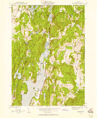
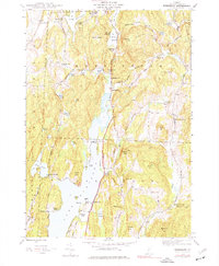
1944 Map of Bomoseen
USGS Topo · Published 1958About this map
Lake Bomoseen dominates this mid-century landscape, acting as a central focal point for a region defined by recreational camps and historic rural settlements. To the north, Hortonville and the Lake Hortonia area show a cluster of activity with the Bangall Sch and seasonal destinations like Beechwood Camp. The central corridor along the Warner Highway reveals the civic heart of Hubbardton, including the Pleasant View Cem and the prominent Monument. Along the eastern ridge, the map documents the quiet agricultural character of East Hubbardton and its namesake East Hubbardton Cem. The western shores of the lake are punctuated by named points like Neshobe Beach and Crystal Beach, while further west, the terrain rises toward Glen Lake and the settlement of West Castleton. This survey provides an essential view of the area's transition into a summer destination while preserving its older network of schoolhouses like Bradley Sch and Parsons Sch.
Find a feature on this map
59 named features on this map. Tap any name to fly to it.
Don’t see what you’re looking for? This feature index may not catch every label — zoom into the map to look around manually.
Map Details
Editions of this 1944 Bomoseen Map
5 editions found
Other maps of this area

1893 · Whitehall
USGS Topo · 1:62,500

1894 · Ticonderoga
USGS Topo · 1:62,500

1895 · Whitehall
USGS Topo · 1:62,500

1895 · Castleton
USGS Topo · 1:62,500

1896 · Ticonderoga
USGS Topo · 1:62,500

1897 · Castleton
USGS Topo · 1:62,500

1898 · Whitehall
USGS Topo · 1:62,500

1902 · Whitehall
USGS Topo · 1:62,500

1902 · Ticonderoga
USGS Topo · 1:62,500

1902 · Brandon
USGS Topo · 1:62,500