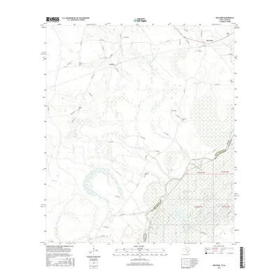
2016 Map of Bon Wier
USGS Topo · Published 2016About this map
The Sabine River serves as the winding natural boundary between Texas and Louisiana, defining the character of this borderland region. In Newton County, the settlements of Bon Wier and Fawil are connected by a network of farm roads and private routes through a landscape heavily influenced by riverine hydrology. The bottomlands are complex, featuring numerous water bodies like Middle River, Wilson Lake, and Wickersham Lake, alongside various sloughs and branches such as Rattlesnake Slough and Dempsey Cr. Genealogical interest is particularly high due to the density of family-named burial sites scattered across the terrain, including Hughes Cem, Belgrade Cem, and Inman Cem. This 2016 survey illustrates how modern road networks like FM 1416 and F-M 363 overlay the older rural fabric of small communities and family landholdings.
Find a feature on this map
72 named features on this map. Tap any name to fly to it.
Don’t see what you’re looking for? This feature index may not catch every label — zoom into the map to look around manually.
Map Details
Editions of this 2016 Bon Wier Map
This is the sole edition of this map. No revisions or reprints were ever made.
Other maps of this area

1935 · Wilson Lake
USGS Topo · 1:31,680

1946 · Merryville
USGS Topo · 1:31,680

1947 · Wilson Lake
USGS Topo · 1:31,680

1947 · Hyatt
USGS Topo · 1:31,680

1947 · Bivens
USGS Topo · 1:31,680

1949 · Bancroft
USGS Topo · 1:31,680

1952 · Lake Charles
USGS Topo · 1:250,000
1954 · Merryville
USGS Topo · 1:31,680
1954 · Bivens
USGS Topo · 1:31,680

1954 · Lake Charles
USGS Topo · 1:250,000