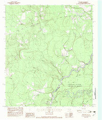
1982 Map of Bon Wier
USGS Topo · Published 1983About this map
The Sabine River winds through this borderland in the early 1980s, marking the boundary between Texas and Louisiana. The landscape is defined by the river’s complex hydrology, featuring numerous sloughs and oxbows such as Rattlesnake Slough and Wilson Lake. Near the center of the sheet, the Beauregard Old River Game and Fish Preserve encompasses a dense network of waterways and wetlands on the Louisiana side, while the Texas side is home to the small settlements of Bon Wier, Belgrade, and Sandjack.
Find a feature on this map
38 named features on this map. Tap any name to fly to it.
Don’t see what you’re looking for? This feature index may not catch every label — zoom into the map to look around manually.
Map Details
Editions of this 1982 Bon Wier Map
This is the sole edition of this map. No revisions or reprints were ever made.
Other maps of this area

1935 · Wilson Lake
USGS Topo · 1:31,680

1946 · Merryville
USGS Topo · 1:31,680

1947 · Wilson Lake
USGS Topo · 1:31,680

1947 · Hyatt
USGS Topo · 1:31,680

1947 · Bivens
USGS Topo · 1:31,680

1949 · Bancroft
USGS Topo · 1:31,680

1952 · Lake Charles
USGS Topo · 1:250,000
1954 · Merryville
USGS Topo · 1:31,680
1954 · Bivens
USGS Topo · 1:31,680

1954 · Lake Charles
USGS Topo · 1:250,000