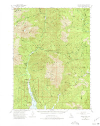
1955 Map of Bonanza King
USGS Topo · Published 1980About this map
The Trinity River and its numerous forks dominate this mid-century survey of the high mountain terrain where the Salmon Mountains meet the Scott Mts. A deep history of resource extraction is evident in the cluster of mining operations scattered across the ridges, including the Altoona Mine, Integral Mine, and the Grand Natl Mine. These sites sit amidst a landscape of isolated outposts such as Carrville and Eagle Creek Ranch, indicating a period when small-scale ranching and prospecting still defined the local economy before the expansion of recreational infrastructure. High-altitude lakes like Tangle Blue Lake and Mumbo Lake punctuate the ridges, while family names on features like Trumble Ranch and Messner Cabin suggest a lineage of early settlers who navigated this complex system of canyons and peaks like Bonanza King and Whisky Bill Peak.
Find a feature on this map
81 named features on this map. Tap any name to fly to it.
Don’t see what you’re looking for? This feature index may not catch every label — zoom into the map to look around manually.
Map Details
Editions of this 1955 Bonanza King Map
4 editions found
Other maps of this area

1886 · Shasta
USGS Topo · 1:250,000

1890 · Red Bluff
USGS Topo · 1:250,000

1894 · Red Bluff
USGS Topo · 1:250,000

1894 · Shasta
USGS Topo · 1:250,000

1901 · Redding
USGS Topo · 1:125,000

1913 · Weaverville
USGS Topo · 1:125,000

1923 · Sawyers Bar
USGS Topo · 1:125,000

1931 · Etna
USGS Topo · 1:96,000

1934 · Etna
USGS Topo · 1:125,000

1935 · Dunsmuir
USGS Topo · 1:125,000