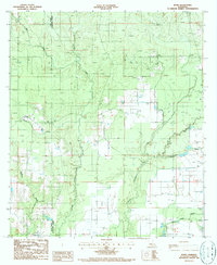
1986 Map of Bond
USGS Topo · Published 1986About this map
The border of Allen Parish and Evangeline Parish defines this mid-1980s landscape, where water management and timber activity shape the terrain. The small community of Bond sits near the upper left, marked by a local Cem and a network of named gullies and creeks. The landscape is heavily structured by a series of linear paths labeled Firebreak, suggesting the importance of forestry or land management in this portion of Louisiana.
Find a feature on this map
17 named features on this map. Tap any name to fly to it.
Don’t see what you’re looking for? This feature index may not catch every label — zoom into the map to look around manually.
Map Details
Editions of this 1986 Bond Map
This is the sole edition of this map. No revisions or reprints were ever made.
Other maps of this area

1935 · Beaver
USGS Topo · 1:31,680

1935 · Oakdale
USGS Topo · 1:31,680

1935 · Turkey Creek
USGS Topo · 1:62,500

1942 · Oakdale
USGS Topo · 1:62,500

1947 · Fruge Lake
USGS Topo · 1:31,680

1947 · Foley
USGS Topo · 1:31,680

1947 · Redland
USGS Topo · 1:31,680

1947 · Bond
USGS Topo · 1:31,680

1949 · Bayou Blue
USGS Topo · 1:31,680

1949 · Turkey Creek
USGS Topo · 1:62,500