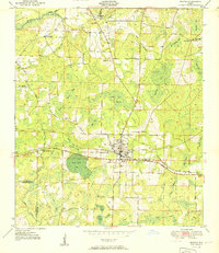
1951 Map of Bonifay
USGS Topo · Published 1951About this map
The city of Bonifay sits as the central hub of this mid-century survey, positioned where the Louisville And Nashville railroad intersects with major regional routes like the Old Spanish Trail and the Geneva Highway. The landscape is characterized by a high density of depression wetlands and bays, including Meetinghouse Bay, Moccasin Bay, and the large Sand Path Bay southwest of the city center.
Find a feature on this map
81 named features on this map. Tap any name to fly to it.
Don’t see what you’re looking for? This feature index may not catch every label — zoom into the map to look around manually.
Map Details
Editions of this 1951 Bonifay Map
3 editions found

Other maps of this area

1949 · Hinsons Cross Roads
USGS Topo · 1:24,000

1949 · Caryville
USGS Topo · 1:24,000

1950 · Hinsons Cross Roads
USGS Topo · 1:24,000

1950 · Caryville
USGS Topo · 1:24,000

1950 · Izagora
USGS Topo · 1:24,000

1950 · Chipley
USGS Topo · 1:24,000

1950 · Wausau
USGS Topo · 1:24,000

1950 · Esto
USGS Topo · 1:24,000

1950 · Poplar Head
USGS Topo · 1:24,000

1951 · Graceville
USGS Topo · 1:24,000