
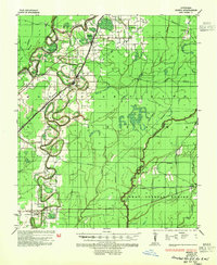
1935 Map of Bonita
USGS Topo · Published 1943About this map
Bartholomew Bayou and the Boeuf River dominate this low-lying landscape in Bonita, where the complex drainage of the Mississippi Delta is traced in fine detail. The settlement patterns follow the higher ground near the Missouri Pacific railroad, which connects the villages of Jones and Bonita. This survey reveals a deeply rooted rural community, evidenced by several country churches such as Mound Chapel Ch, Green Grove Ch, and Rawson Chapel, alongside the Johnson Sch. The transportation network of the 1930s is particularly well-documented, showing the transition from river-based transit like Loverett Ferry to overland routes like Louisiana State Highway No 11 and the Louisiana and Arkansas rail line. The presence of a gas pipe line and the identified Head of Navigation on the river reflect the industrial underpinnings of this agricultural region.
Find a feature on this map
29 named features on this map. Tap any name to fly to it.
Don’t see what you’re looking for? This feature index may not catch every label — zoom into the map to look around manually.
Map Details
Editions of this 1935 Bonita Map
2 editions found
Other maps of this area

1935 · Collinston
USGS Topo · 1:62,500

1935 · Wilmot
USGS Topo · 1:62,500

1935 · Naff
USGS Topo · 1:62,500

1935 · Hurricane
USGS Topo · 1:62,500

1935 · Oak Grove
USGS Topo · 1:62,500

1936 · Eudora
USGS Topo · 1:62,500

1953 · Greenwood
USGS Topo · 1:250,000

1955 · Jackson
USGS Topo · 1:250,000

1956 · Greenwood
USGS Topo · 1:250,000

1956 · Bastrop
USGS Topo · 1:62,500