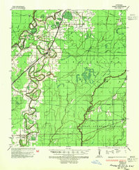
1935 Map of Bonita
USGS Topo · Published 1954About this map
Bonita serves as the central hub of this Mississippi Delta landscape, where the Missouri Pacific railroad cuts a straight line through the alluvial plains of Morehouse Parish. The map reveals a complex hydraulic environment defined by the winding course of Bayou Bartholomew and the Boeuf River, which forms the boundary with West Carroll Parish. At the Head of Navigation on the Boeuf, the transition from river transport to rail-based commerce is evident. Rural community life is anchored by several local landmarks, including Mound Chapel Ch, Rawson Chapel, and Johnson Sch. The eastern portion of the quadrangle is marked by seasonal wetlands and bayous such as Coffee Bayou and Camp Bayou, illustrating the drainage patterns that shaped early agricultural development in northern Louisiana before later 20th-century modifications.
Find a feature on this map
30 named features on this map. Tap any name to fly to it.
Don’t see what you’re looking for? This feature index may not catch every label — zoom into the map to look around manually.
Map Details
Editions of this 1935 Bonita Map
2 editions found
Other maps of this area

1935 · Collinston
USGS Topo · 1:62,500

1935 · Wilmot
USGS Topo · 1:62,500

1935 · Naff
USGS Topo · 1:62,500

1935 · Hurricane
USGS Topo · 1:62,500

1935 · Oak Grove
USGS Topo · 1:62,500

1935 · Bonita
USGS Topo · 1:62,500

1936 · Eudora
USGS Topo · 1:62,500

1953 · Greenwood
USGS Topo · 1:250,000

1955 · Jackson
USGS Topo · 1:250,000

1956 · Greenwood
USGS Topo · 1:250,000