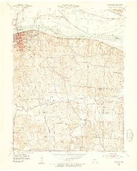
1952 Map of Boonville
USGS Topo · Published 1953About this map
Boonville serves as a prominent river port and institutional hub along the south bank of the Missouri River in this early 1950s survey. The landscape is defined by its significant educational and civic landmarks, including the Kemper Military Sch and the State Boys School, alongside the Courthouse and St Joseph Convent. Transport and commerce are anchored by the Missouri Pacific and Missouri Kansas Texas railroads, which parallel the river and the northern edge of the bluff. South of the city, the terrain transitions into a dense network of rural school districts and family-named watercourses. Researchers can identify numerous local schoolhouses such as Hall Ridge Sch, Crab Orchard Sch, and Bluffton Sch, illustrating the dispersed settlement pattern in Cooper County before the consolidation of rural districts. The map also captures several sites already noted as obsolete by 1952, including the Woodland Sch (Abandoned).
Find a feature on this map
37 named features on this map. Tap any name to fly to it.
Don’t see what you’re looking for? This feature index may not catch every label — zoom into the map to look around manually.
Map Details
Editions of this 1952 Boonville Map
3 editions found
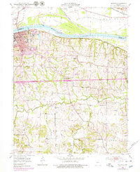
Other maps of this area

1888 · Boonville
USGS Topo · 1:125,000

1890 · Glasgow
USGS Topo · 1:125,000

1947 · Glasgow
USGS Topo · 1:62,500

1947 · Jefferson City
USGS Topo · 1:250,000

1952 · Rocheport
USGS Topo · 1:24,000

1952 · Boonville
USGS Topo · 1:24,000

1952 · New Franklin
USGS Topo · 1:24,000
1952 · Prairie Home
USGS Topo · 1:24,000

1952 · Hilldale
USGS Topo · 1:24,000

1952 · Lone Elm
USGS Topo · 1:24,000