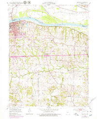
1952 Map of Boonville
USGS Topo · Published 1979About this map
Boonville sits prominently along the southern bank of the Missouri River, serving as a critical junction for the Pacific railroad and highway transport during the mid-20th century. The landscape is defined by the significant floodplain of Franklin Island to the north and the dissection of the southern uplands by Petite Saline Creek and its tributaries. Educational and institutional history is well-represented by the State Boys School and several rural schoolhouses like Bluffton Sch and Hail Ridge Sch. To the south, the agricultural character of the region is evident in the scattered settlements of Merna and Clarks Fork. Cultural landmarks, including St Joseph Convent and the sprawling Walnut Grove Cem, anchor the community's local history, while the presence of the Boonville Airport and Jesse Viertel Memorial Airport marks the era's transitioning infrastructure.
Find a feature on this map
38 named features on this map. Tap any name to fly to it.
Don’t see what you’re looking for? This feature index may not catch every label — zoom into the map to look around manually.
Map Details
Editions of this 1952 Boonville Map
3 editions found
Other maps of this area

1888 · Boonville
USGS Topo · 1:125,000

1890 · Glasgow
USGS Topo · 1:125,000

1947 · Glasgow
USGS Topo · 1:62,500

1947 · Jefferson City
USGS Topo · 1:250,000

1952 · Rocheport
USGS Topo · 1:24,000

1952 · Boonville
USGS Topo · 1:24,000

1952 · New Franklin
USGS Topo · 1:24,000
1952 · Prairie Home
USGS Topo · 1:24,000

1952 · Hilldale
USGS Topo · 1:24,000

1952 · Lone Elm
USGS Topo · 1:24,000