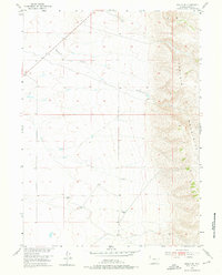
1955 Map of Bosler SE
USGS Topo · Published 1976About this map
The Laramie Mountains dominate the eastern reaches of this landscape, where the high-altitude terrain drops sharply toward the basin floor. This mid-century survey captures a region defined by its hydrology and livestock infrastructure, featuring the perennial flows of Wallrock Creek and Gates Creek. The drainage patterns here are essential for understanding the early 20th-century ranching economy, further evidenced by the numerous Windmill sites scattered across the plains to support water access in a semi-arid environment. An artificial Ditch in the northwest and a small Gravel Pit suggest the ongoing human modifications to the land for irrigation and road maintenance. The cartography reveals a sparsely populated area where the township and range lines of T. 19 N. T. 18 N. and R. 73 W. R. 72 W. provide the primary structural framework for land ownership and movement through the territory.
Find a feature on this map
9 named features on this map. Tap any name to fly to it.
Don’t see what you’re looking for? This feature index may not catch every label — zoom into the map to look around manually.
Map Details
Editions of this 1955 Bosler SE Map
3 editions found

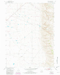
Other maps of this area

1895 · Laramie
USGS Topo · 1:125,000

1902 · Laramie
USGS Topo · 1:125,000

1905 · Sherman
USGS Topo · 1:125,000

1905 · Laramie
USGS Topo · 1:125,000

1906 · Laramie
USGS Topo · 1:125,000

1908 · Laramie
USGS Topo · 1:125,000

1948 · Ragged Top Mountain
USGS Topo · 1:62,500

1950 · Ragged Top Mountain
USGS Topo · 1:62,500

1954 · Cheyenne
USGS Topo · 1:250,000

1955 · Bosler
USGS Topo · 1:24,000