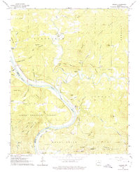
1964 Map of Boswell
USGS Topo · Published 1975About this map
The White River carves a deep valley through the limestone bluffs of the Ozarks, serving as the defining border between Izard and Stone counties. This mid-century landscape is marked by the winding route of the Missouri Pacific railroad, which tracks the river's edge past the settlement of Boswell. Higher elevations are defined by isolated peaks like Hall Mountain and Twin Mountain, where small family-named cemeteries such as Hall Mountain Cem and Spring Jones Cem hint at early upland homesteads.
Find a feature on this map
73 named features on this map. Tap any name to fly to it.
Don’t see what you’re looking for? This feature index may not catch every label — zoom into the map to look around manually.
Map Details
Editions of this 1964 Boswell Map
4 editions found
Other maps of this area

1890 · Batesville
USGS Topo · 1:125,000

1890 · Mountain Home
USGS Topo · 1:125,000

1891 · Mountain Home
USGS Topo · 1:125,000

1891 · Batesville
USGS Topo · 1:125,000

1892 · Mountain View
USGS Topo · 1:125,000

1894 · Mountain View
USGS Topo · 1:125,000

1894 · Mountain Home
USGS Topo · 1:125,000

1945 · Harrison
USGS Topo · 1:250,000

1949 · Harrison
USGS Topo · 1:250,000

1951 · Melbourne
USGS Topo · 1:62,500