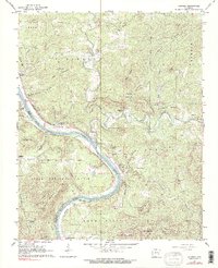
1964 Map of Boswell
USGS Topo · Published 1990About this map
White River meanders through the heart of this mid-century survey, defining the border between Izard and Stone counties. The landscape is characterized by its reliance on the river and rail, with the Missouri Pacific railroad following the water's edge past Bone Island. Small riverside and upland settlements like Boswell, Optimus, and Gorby serve as the primary hubs for rural life.
Find a feature on this map
74 named features on this map. Tap any name to fly to it.
Don’t see what you’re looking for? This feature index may not catch every label — zoom into the map to look around manually.
Map Details
Editions of this 1964 Boswell Map
4 editions found
Other maps of this area

1890 · Batesville
USGS Topo · 1:125,000

1890 · Mountain Home
USGS Topo · 1:125,000

1891 · Mountain Home
USGS Topo · 1:125,000

1891 · Batesville
USGS Topo · 1:125,000

1892 · Mountain View
USGS Topo · 1:125,000

1894 · Mountain View
USGS Topo · 1:125,000

1894 · Mountain Home
USGS Topo · 1:125,000

1945 · Harrison
USGS Topo · 1:250,000

1949 · Harrison
USGS Topo · 1:250,000

1951 · Melbourne
USGS Topo · 1:62,500