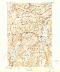
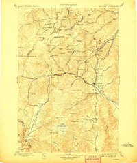
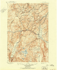
1899 Map of Boulder
USGS Topo · Published 1933About this map
Boulder serves as the focal point of this late 19th-century study, situated at the confluence of the Boulder River and Muskrat Creek. The landscape is dominated by the hard-rock mining industry of the Northern Rockies, featuring an extensive network of claims like the Free Coinage Mine, Grey Eagle Mine, and the Amazon Mill. Heavy rail infrastructure from the Montana Central R.R. and Northern Pacific R.R. dictates the pattern of settlement, threading through steep passes to connect industrial hubs like Wickes and Corbin.
Find a feature on this map
114 named features on this map. Tap any name to fly to it.
Don’t see what you’re looking for? This feature index may not catch every label — zoom into the map to look around manually.
Map Details
Editions of this 1899 Boulder Map
4 editions found
Other maps of this area

1886 · Fort Logan
USGS Topo · 1:250,000

1888 · Three Forks
USGS Topo · 1:250,000

1889 · Helena
USGS Topo · 1:250,000

1893 · Helena
USGS Topo · 1:250,000

1893 · Dillon
USGS Topo · 1:250,000

1894 · Three Forks
USGS Topo · 1:250,000

1895 · Three Forks
USGS Topo · 1:250,000

1899 · Boulder
USGS Topo · 1:125,000

1899 · Helena
USGS Topo · 1:62,500

1899 · Helena
USGS Topo · 1:250,000