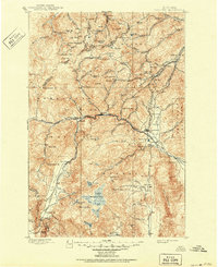
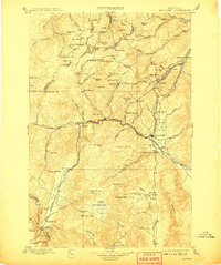
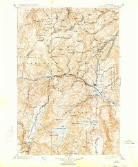
1899 Map of Boulder
USGS Topo · Published 1951About this map
Boulder serves as the focal point of this late 19th-century Montana landscape, where the Montana Central R. R. and the Northern Pacific R. R. Elkhorn Branch converge in the Boulder Valley. The region is defined by an intensive mining economy, with dozens of active operations such as the Hidden Treasure Mine, Mina Mine, and Frohner Mine peppering the surrounding peaks. This survey captures a specific industrial moment when the Amazon Mill operated alongside early recreation sites like Boulder Hot Springs. High-altitude placer mining is evident at Penn Placer and Yellowstone Placer, indicating the diversity of extraction methods used across the Helena National Forest and Deerlodge National Forest. Significant transportation hubs like Basin and Wickes anchor the rail lines, while the Butte Hospital marks the edge of expanding social infrastructure in the southwest.
Find a feature on this map
101 named features on this map. Tap any name to fly to it.
Don’t see what you’re looking for? This feature index may not catch every label — zoom into the map to look around manually.
Map Details
Editions of this 1899 Boulder Map
4 editions found
Other maps of this area

1886 · Fort Logan
USGS Topo · 1:250,000

1888 · Three Forks
USGS Topo · 1:250,000

1889 · Helena
USGS Topo · 1:250,000

1893 · Helena
USGS Topo · 1:250,000

1893 · Dillon
USGS Topo · 1:250,000

1894 · Three Forks
USGS Topo · 1:250,000

1895 · Three Forks
USGS Topo · 1:250,000

1899 · Boulder
USGS Topo · 1:125,000

1899 · Helena
USGS Topo · 1:62,500

1899 · Helena
USGS Topo · 1:250,000