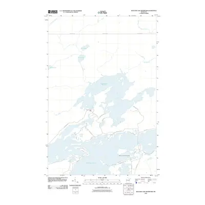
2010 Map of Boulder Lake Reservoir
USGS Topo · Published 2010About this map
Boulder Lake Reservoir and Island Lake Reservoir dominate this landscape north of Duluth, illustrating the extensive hydrological management of the Cloquet River watershed. The placement of the Boulder Lake Dam regulates the flow through a series of interconnected basins and smaller water bodies like Nevens Lake and the Twin Lakes. This complex system of reservoirs is a hallmark of the region's utilities and recreation, supporting unique facilities such as the North Country Seaplane Base on the northern reaches of Island Lake. The road network, including Breezy Point Rd and Tomahawk Point Rd, highlights a shift toward seasonal residency and recreational access around the shoreline. Along the northern edge, the Us-Kab-Wan-Ka River and Boulder Creek feed into this managed system, while local routes like Three Lakes Rd provide access to the quieter, smaller lakes including Apple Lake.
Find a feature on this map
29 named features on this map. Tap any name to fly to it.
Don’t see what you’re looking for? This feature index may not catch every label — zoom into the map to look around manually.
Map Details
Editions of this 2010 Boulder Lake Reservoir Map
This is the sole edition of this map. No revisions or reprints were ever made.
Other maps of this area

1895 · Duluth
USGS Topo · 1:62,500

1953 · Twig
USGS Topo · 1:24,000

1953 · Shaw
USGS Topo · 1:24,000

1953 · Arnold
USGS Topo · 1:24,000

1953 · Boulder Lake Reservoir
USGS Topo · 1:24,000

1953 · Fredenberg
USGS Topo · 1:24,000

1953 · Duluth
USGS Topo · 1:62,500

1953 · Duluth
USGS Topo · 1:250,000

1954 · Thompson Lake
USGS Topo · 1:24,000

1954 · Hibbing
USGS Topo · 1:250,000