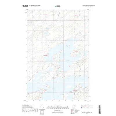
2019 Map of Boulder Lake Reservoir
USGS Topo · Published 2019About this map
Boulder Lake Reservoir and Island Lake Reservoir dominate this northern Minnesota landscape, where the managed waters of the Cloquet River and Otter River define the local topography. This 2019 survey captures the complex shoreline of these reservoirs, which are punctuated by numerous small islands and fingers of land like Breezy Point Rd. The intricate road network, including uniquely named ways such as Some Quiet Pl and Birch Isle Rd, suggests a region deeply tied to seasonal recreation and shoreline living. In the northern reaches, the Us-Kab-Wan-Ka River flows through more secluded terrain near Twin Lakes, while the southern portion of the map shows the structured dike system around the Island Lake Reservoir near N Dike Rd. This documentation of water management and rural access provides a clear view of the area's modern hydrological and transport patterns.
Find a feature on this map
42 named features on this map. Tap any name to fly to it.
Don’t see what you’re looking for? This feature index may not catch every label — zoom into the map to look around manually.
Map Details
Editions of this 2019 Boulder Lake Reservoir Map
This is the sole edition of this map. No revisions or reprints were ever made.
Other maps of this area

1895 · Duluth
USGS Topo · 1:62,500

1953 · Twig
USGS Topo · 1:24,000

1953 · Shaw
USGS Topo · 1:24,000

1953 · Arnold
USGS Topo · 1:24,000

1953 · Boulder Lake Reservoir
USGS Topo · 1:24,000

1953 · Fredenberg
USGS Topo · 1:24,000

1953 · Duluth
USGS Topo · 1:62,500

1953 · Duluth
USGS Topo · 1:250,000

1954 · Thompson Lake
USGS Topo · 1:24,000

1954 · Hibbing
USGS Topo · 1:250,000