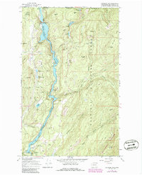
1967 Map of Boundary Dam
USGS Topo · Published 1986About this map
Pend Oreille River anchors this corner of the Pacific Northwest, captured during the late 1960s just as the Boundary Dam transformed the landscape with its reservoir. The map reveals an intensive mining corridor along the river's banks, including the Josephine Mine, Lucky Strike Mine, and the Pend Oreille Mine, illustrating the region's industrial dependence on lead and zinc extraction. These workings are concentrated near the southern boundary, where Tailings and various Drill Hole markers indicate the scale of subterranean activity.
Find a feature on this map
54 named features on this map. Tap any name to fly to it.
Don’t see what you’re looking for? This feature index may not catch every label — zoom into the map to look around manually.
Map Details
Editions of this 1967 Boundary Dam Map
2 editions found
Other maps of this area

1934 · Metaline
USGS Topo · 1:125,000

1942 · Metaline
USGS Topo · 1:125,000

1958 · Sandpoint
USGS Topo · 1:250,000

1963 · Sandpoint
USGS Topo · 1:250,000

1967 · Gypsy Peak
USGS Topo · 1:24,000

1967 · Boundary Dam
USGS Topo · 1:24,000

1967 · Metaline
USGS Topo · 1:24,000

1967 · Metaline Falls
USGS Topo · 1:24,000

1967 · Pass Creek
USGS Topo · 1:24,000
1967 · Abercrombie Mtn
USGS Topo · 1:24,000