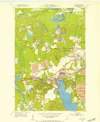
1952 Map of Bovey
USGS Topo · Published 1954About this map
The industrial heart of the Mesabi Range is captured in this early 1950s survey, dominated by a massive network of open-pit extraction sites and heavy rail infrastructure. The interconnected settlements of Coleraine, Bovey, and Taconite are shown at their mid-century peak, bordered by sprawling operations like the Canisteo Mine and Morrison Mine. A defining characteristic of the landscape is the sheer volume of material movement, evidenced by numerous Tailings Ponds and vast Mine Dumps that reshape the natural topography between the Prairie River and the deep waters of Trout Lake.
Find a feature on this map
40 named features on this map. Tap any name to fly to it.
Don’t see what you’re looking for? This feature index may not catch every label — zoom into the map to look around manually.
Map Details
Editions of this 1952 Bovey Map
4 editions found
Other maps of this area

1920 · Trout Lake
USGS Topo · 1:62,500

1952 · Calumet
USGS Topo · 1:24,000

1952 · Bovey
USGS Topo · 1:24,000

1953 · Cohasset East
USGS Topo · 1:24,000

1953 · Grand Rapids
USGS Topo · 1:24,000

1954 · Hibbing
USGS Topo · 1:250,000

1957 · Hibbing
USGS Topo · 1:250,000

1958 · Hibbing
USGS Topo · 1:250,000

1964 · Hibbing
USGS Topo · 1:250,000

1969 · La Prairie
USGS Topo · 1:24,000