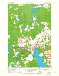
1952 Map of Bovey
USGS Topo · Published 1968About this map
The industrial heart of Minnesota’s Iron Range is laid bare in this mid-century survey, centered on the mining communities of Bovey, Coleraine, and Taconite. The landscape is defined by the massive operations of the Canisteo Mine, Holman Cliffs Mine, and Walker Mine, where deep excavations are flanked by extensive Mine Dumps and Tailings Ponds. These industrial features radically reshape the natural topography of the Mesabi Range, pushing right against the residential edges of the villages.
Find a feature on this map
41 named features on this map. Tap any name to fly to it.
Don’t see what you’re looking for? This feature index may not catch every label — zoom into the map to look around manually.
Map Details
Editions of this 1952 Bovey Map
4 editions found
Other maps of this area

1920 · Trout Lake
USGS Topo · 1:62,500

1952 · Calumet
USGS Topo · 1:24,000

1952 · Bovey
USGS Topo · 1:24,000

1953 · Cohasset East
USGS Topo · 1:24,000

1953 · Grand Rapids
USGS Topo · 1:24,000

1954 · Hibbing
USGS Topo · 1:250,000

1957 · Hibbing
USGS Topo · 1:250,000

1958 · Hibbing
USGS Topo · 1:250,000

1964 · Hibbing
USGS Topo · 1:250,000

1969 · La Prairie
USGS Topo · 1:24,000