
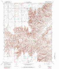
1966 Map of Bowers City
USGS Topo · Published 1970About this map
The North Fork Red River carves a complex drainage system through Gray County, where the industrial landscape of the Texas Panhandle is defined by an extensive Gas and Oil Field. This 1966 survey documents the infrastructure supporting the region's energy economy, including a Refinery, a Pumping Sta, and multiple Gravel Pit operations. The small settlement of Bowers City sits at the nexus of these activities, surrounded by family-named landmarks like Reeves and essential utilities such as a Radio Tower and various water tanks. Transportation in the area is anchored by the Fort Worth and Denver railroad, which cuts across the northern terrain. Hydrological features such as Grapevine Creek and its South Fork Grapevine Creek illustrate the natural runoff patterns that coexist with the heavy pipeline and drilling footprints of the mid-twentieth century.
Find a feature on this map
14 named features on this map. Tap any name to fly to it.
Don’t see what you’re looking for? This feature index may not catch every label — zoom into the map to look around manually.
Map Details
Editions of this 1966 Bowers City Map
2 editions found
Other maps of this area

1954 · Amarillo
USGS Topo · 1:250,000

1958 · Amarillo
USGS Topo · 1:250,000

1963 · Pampa
USGS Topo · 1:24,000

1965 · Lake Mc Connell
USGS Topo · 1:24,000

1966 · Grandview School
USGS Topo · 1:24,000

1966 · Kingsmill
USGS Topo · 1:24,000

1967 · Lefors
USGS Topo · 1:24,000

1967 · Hoover
USGS Topo · 1:24,000

1968 · Taylor Ranch
USGS Topo · 1:24,000
1968 · Deep Lake
USGS Topo · 1:24,000