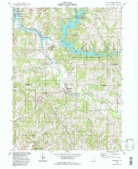
1994 Map of Bowerston
USGS Topo · Published 1998About this map
Leesville Lake dominates the upper half of this landscape, a product of the Muskingum Watershed Conservancy District flood control efforts. The impounded waters of McGuire Creek and the North Fork create a branching shoreline that winds through the steep valleys of Orange and Perry townships. The local economy and geography are defined by resource extraction and transportation, evidenced by numerous Strip Mines, a Claypit, and the Old Railroad Grade passing through Leesville. On the southern edge, Plum Run flows toward the Carroll and Harrison County line, where small rural landmarks like the Plum Run Ch and Heller Cem anchor long-standing family communities. The village of Bowerston serves as a central hub in the lower valley, situated where the terrain transitions toward Tupnel Hill.
Find a feature on this map
37 named features on this map. Tap any name to fly to it.
Don’t see what you’re looking for? This feature index may not catch every label — zoom into the map to look around manually.
Map Details
Editions of this 1994 Bowerston Map
This is the sole edition of this map. No revisions or reprints were ever made.
Other maps of this area

1902 · Scio
USGS Topo · 1:62,500

1904 · Scio
USGS Topo · 1:62,500

1909 · Uhrichsville
USGS Topo · 1:62,500

1910 · Carrollton
USGS Topo · 1:62,500

1911 · Uhrichsville
USGS Topo · 1:62,500

1912 · Dover
USGS Topo · 1:62,500

1912 · Carrollton
USGS Topo · 1:62,500

1944 · Dover
USGS Topo · 1:62,500

1951 · Canton
USGS Topo · 1:250,000

1953 · Canton
USGS Topo · 1:250,000